Revolutionizing Agritech with Deep Learning-Enhanced Remote Sensing for Precision Agricultural Management
Authors :
Hudsein Haider and Dr. B.Lavanya
Address :
Dept of Medical instruments engineering techniques, Al-farahidi University, Baghdad
Dept of Computer Science, Periyar University, Salem
Abstract :
A new method of farm management that makes use of cutting-edge information technology is known as precision agriculture management. By reducing the waste of water, fertilizers, pesticides, fuel, and other types of agricultural inputs, as well as by optimizing agrarian income and limiting adverse effects on the environment, precision agriculture management seeks to boost agricultural output and quality. Traditional agricultural management methods often lead to inefficient use of resources, higher environmental impacts, and decreased crop yields. Finding efficient, scalable, and accurate ways to track important agricultural variables over large regions is a huge challenge. This paper proposes a new framework called ARS-DLConvNN to handle these issues and enhance the management of agritech and precise agriculture. This framework Integrates High-Resolution Agricultural Remote Sensing (ARS) data and Deep Learning (DL) methods like Convolutional Neural Networks (ConvNN). This approach uses Convolutional Neural Networks (CNNs) and Long Short-Term Memory (LSTM) network specifically designed to handle hyperspectral data collected from UAVs and multi-spectral satellite photos. These algorithms can assess crop stress in real-time, provide recommendations on effectively managing water, fertilizer, and insects, and learn to estimate weight and yield. It will be quite easy to see how the proposed method improves agriculture management effectiveness and harvest yields. Improved agricultural management efficiency and crop production were striking when using the suggested deep-learning remote sensing system. On average, crop yields increased by 18% compared to traditional methods, according to field trials in various locations. decrease output. With a 92% success rate in detecting crop illnesses early and an 89% success rate in forecasting water stress, the model allowed for prompt treatments.
Keywords :
Remote Sensing; Deep Learning method; Convolutional Neural Network; Precision Agricultural Management; Long Short-Term Memory Network.
1.Introduction
Agriculture is crucial in the global economy since it produces food and fibre, which are humanity's fundamental requirements. The last century's Green Revolution and other technological advancements have revolutionized farming [1]. Even though half of the global population has moved into cities or industrialized, half still work in agriculture. For instance, in India, most people are still involved in agriculture [2]. According to the Food and Agriculture Organization (FAO), the demand for high-quality, sustainably produced food is expected to increase by 70% by 2050 [3]. Given the difficult circumstances in agriculture, it is crucial to closely observe the development and condition of crops in different areas and environmental conditions, using different time intervals and for diverse objectives [4]. Simultaneously, climate change, urbanization, and excessive agricultural exploitation will significantly reduce the amount of arable land suitable for food production, resulting in severe challenges in maintaining a balance between production and consumption [5]. Any illness that induces significant morphological and physiological alterations in crop plants can be considered an appropriate candidate for remotely sensed detection. In the late 1920s, a conventional film-based camera was employed from an aeroplane to obtain aerial images of cotton fields affected by cotton root decay, a soil-borne infection caused by the fungus Phymatotrichopsis omnivorous [6]. An effectively crafted insurance scheme might incentivize farmers to make profitable purchases, such as in crops and fertilizer, that have the potential to enhance their revenue under normal circumstances but are susceptible to adverse weather conditions [7].
Precision Agriculture (PA) uses extensive data sources and sophisticated analytical tools related to crops and the environment. Its goal is to help farmers apply the proper rate at the right moments and places so they can manage their fields successfully and make educated judgments. The ultimate objective is to achieve economic and environmental goals [8]. Remote Sensing Systems is an interdisciplinary scientific field encompassing various disciplines, including Spectroscopy imaging, gadgets, pictures, satellite taking off, electronics, and communication [9]. One PA technology, remote sensing (RS), makes it easy and affordable for farmers to track the condition of their crops and soil at different points in the production process. Using it as a warning sign can help find issues before they escalate, giving you more time to fix them [10]. Deep Learning prioritizes the complexity of the model's structure, emphasizes the significance of acquiring features, and suggests several methods to improve the teaching of more advanced and efficient features [11]. An increasing number of agricultural scientists are focusing on utilizing deep learning for image-based observations in farming, including tasks like land mapping, crop classification, biotic and abiotic stress monitoring, and predicting crop production [12].
The main contribution of this paper is
- It detects problems, including water stress, nutrient deficits, and bug infestations, with over 90% accuracy, which helps farmers with trouble spotting the early signs of crop stress.
- The proposed ARS-DLConvNN approach limits of conventional agricultural management techniques can be overcome and crop health and field conditions can be monitored at high geographical and temporal resolutions.
- This proposed framework allows for accurate resource allocation and intervention, maximizing output in changing climate conditions.
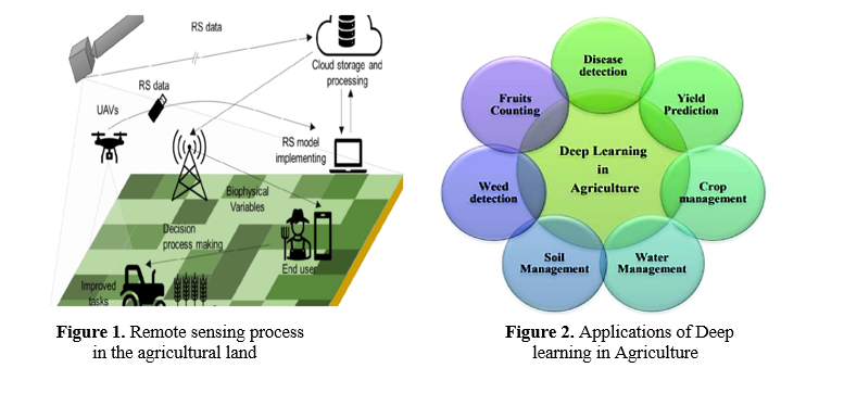
Figure 1 shows the process of the remote sensors on agricultural land. The uses of DL in farming are illustrated in Figure 2. This study investigates how deep learning in remote sensing might significantly improve precision agriculture management in agritech. This study's goal is to create a highly accurate system that uses excellent-quality satellite and drone photos, advanced neural networks, and precise algorithms to track crop conditions, predict yields, identify abnormalities, and provide targeted actions. The proposed ARS-DLConvNN approach can increase agricultural productivity while improving sustainability by optimising water, fertilizer, and pesticides. Also, bridging the gap between cutting-edge research and practical application can help level the playing field regarding access to high-tech agricultural equipment by making data collected via remote sensing available to farmers through smartphone apps.
2.Literature Survey
In their study, Karunathilake et al. [13] investigated cutting-edge developments in PA, emphasising the use of big data and the IoT. The most recent successes, failures, and prospective developments in innovative farming and precision agriculture are summarised in this review article. The article delves into the current state of PA using cutting-edge tech like sensors, unmanned aircraft, and machine learning. In addition, these technology's adaptability to various farming settings can limit their applicability in some regions. The only way to address these issues is to create educational and training programs that teach farmers how to use this technology effectively.
A data query system was integrated by Martínez, N. L. et al. [14] to facilitate the automation of tasks, decision-making, and ordinary questions by users and farmers alike. The proposal showcased a system that ensured service connectivity and was tested on two smart agricultural platforms in Europe, DEMETER and AFarCloud. The suggested framework is tested and verified using a neural network. Accurate forecasts regarding the timing of harvesting and packing foraging legume crops utilized as cow feed are produced by the neural network, which is trained and tested using STSDaMaS. Analyzing how neural networks are trained and run shows they are quite good at answering complex spatiotemporal semantic queries.
The possible advantages of precision agricultural technology in developing environmentally conscious and sustainable agriculture were investigated by Gawande V. et al. [15]. Less waste and less environmental impact are the results of precision farming techniques that allow for the perfect distribution of resources like water, fertilizer, and pesticides. Precision farming equips farmers with up-to-the-minute information that boosts crop yields through better management and informed decision-making using cutting-edge technology such as GPS, GIS, remote sensing, and data analytics. But it's expensive and doesn't give you enough knowledge, expertise, or access to necessary technology.
Aiming to evaluate WSNs' capacity to manage growing agricultural workloads, Atalla S. et al. [16] set out to do just that. The assessment will include two cases: farms that grow olive trees and horse training facilities. This article introduces a new way to classify agricultural Internet of Things apps based on several parameters. Further, it presents criteria for assessment that may be used to examine how well scenario types (stationary and mobile) work on 6LowPAN networks. In two agricultural scenarios, the study models and simulates the functioning of the routing protocols and 6LowPAN for networks with low power and loss (RPL) using COOJA, a practical Wireless Sensor Network (WSN) simulator. There is a risk that the suggested framework's real performance in precision farming applications will not be faithfully reflected in the simulated findings using this methodology.
The present state of UAV technology for directing PA activities on smallholder farms was evaluated in a thorough literature review by Gokool S. et al. [17]. Unmanned Aerial Vehicles (UAVs) have evolved into powerful instruments for crop monitoring and PA method guidance. Improved agricultural productivity and more efficient use of vital resources could be possible with this technique. Results from these studies show that UAVs are primarily employed for crop mapping, fertilizer management recommendations, and crop growth monitoring. However, our study's findings may not be generalizable because they were based on subjective criteria and procedures used to compile and evaluate the data.
Santos L. et al. [18] comprehensively examined numerous deep-learning methodologies in diverse agricultural contexts, including disease identification, fruit/plant classification, and fruit counting. The paper examines the models utilized, data sources, research performance, hardware, and the possibility of real-time applications to explore the possibility of integration with autonomous robotic platforms. The primary drawback may lie in the hardware limitation, as these systems predominantly rely on high-performance GPUs that necessitate significant power consumption.
Krishnababu, M. E. et al. [19] highlighted how AI and IoT transform farming methods as they examine PA's history and the present situation in India. Better crop and soil monitoring, disease diagnostics, and yield prediction are all made possible with the use of AI's forecasting and machine-learning models, which in turn improve decision-making. Smarter resource management and operational efficiency are made possible by the Internet of Things (IoT), which improves these capabilities by providing the framework for data collection and real-time monitoring. Despite the enormous promise of these technologies, several important obstacles must be overcome for their successful deployment, including high costs, complex technological issues, and socioeconomic inequality.
Issa H. et al. [20] created a thorough framework that examines the factors influencing AI readiness and identifies important strategic components that might assist agritech companies in effectively managing their preparation for AI implementation. We utilize a mixed-methods strategy to gather data, employing 236 e-surveys and conducting 25 interviews at a very influential AgriTech conference. Collecting data from a very influential conference in the AgriTech sector restricts the sample size for quantitative and qualitative inquiries.
In their literature review, Velusamy et al. [21] summed up the best practices for employing UAVs and other unmanned aircraft to precisely monitor crops and manage pests in agricultural fields. When using UAVs for early disease detection in agriculture, the researchers comprehensively review and compare the available data. Along with the Quality of Service (QoS), this study investigates using UAV, satellite, and other forms of remote sensing for illness diagnosis. Tracking procedures and UAV operations are hindered by inclement weather, which includes snowfall, cloud cover, fog, and precipitation.
Using a deep learning predictor with a progressive two-level decomposition structure, Jin, X. B. et al. [22] improved the accuracy of the weather-related predictions made by the PA IoT system. First, divide the weather data into four sections. Then, train GRU network to sub-predict one section. We integrated the outputs from GRUs to acquire the findings for a medium and long-term predictions. A more complex model requiring more processing power may result from using a two-level segmentation and integrating many GRU networks.
An Empirical Mode Decomposition (EMD) approach and a Gated Recurrent Unit (GRU) network are combined in a hybrid deep learning predictor [23] developed by Yang, N. X., et al. First, to better understand the climatic data, apply the EMD approach and partition it into different groups based on frequency. Next, each group's training uses a GRU network as a sub-predictor. After adding all the outputs from all the GRU networks, this study gets the final forecast. Testing the suggested model with weather data collected by an agricultural IoT system proved its viability. The reliability of the forecast depends on a mountain of high-quality climatic data. Too noisy, insufficient, or inconsistent data can make the EMD the CNN and GRU models that follow less accurate and inefficient.
3.Proposed Methodology
a. Dataset Explanation
Achieving optimal production and long-term viability in farming relies heavily on accurate crop recommendations. The importance of using thorough statistics, particularly those about soil composition, is growing as farmers and agricultural specialists delve further into data-driven approaches. There is a variety of information in the dataset that is being considered, including levels of important components like phosphorus, potassium, and nitrogen, as well as environmental factors like humidity, temperature, pH value, and rainfall. It is essential to comprehend and analyse this dataset to make sound decisions that could improve agricultural output, resource management, and general crop health. Using soil data to inform crop selection is crucial in contemporary farming. Profitability, sustainability, crop productivity, managing resources, and climate resistance can all be enhanced by include information on the soil and other environmental factors in large datasets. Adopting data-driven decision-making, the basis of efficient crop recommendation systems, can lead to a better agricultural future.
b. ARS-DLConvNN Framework in Precision Agricultural Management
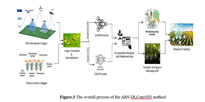
A high-level view of the proposed ARS-DLConvNN method for managing precision agriculture is shown in Figure 3. This system is fed data from satellites, as well as ground sensors and unmanned aerial vehicles (UAVs). Improving, standardizing, and fixing the obtained raw images are all part of the preprocessing steps. The next phase features extraction, which uses CNNs for spatial evaluation and LSTM networks for temporal analysis. The conventional approach feeds these combined spatial and temporal features into comparative analytics algorithms. The ARS-DLConvNN method uses high-resolution images and sophisticated machine-learning algorithms to enhance production, environmental responsibility, and farmers' decision-making.
b.1 Data Collection and Preprocessing
Satellite photographs (such as those from Sentinel-2 and Landsat) and sensor-equipped unmanned aerial vehicles (UAVs) provide most of this system's input data. This study adds readings from sensors and field evaluations to this data to ensure that crop condition, soil moisture, nutrient levels, and insect infestations are accurately assessed.
Several crucial preprocessing operations are carried out before the guarantee of correct and consistent initial data is analysed. These steps include correcting images, normalizing data, and using augmentation techniques.
b.1.1 Methods of Image Correction
Minimizing the influence of the atmosphere and the sensor is essential for accurate scene capture. One way to improve the accuracy of surface reflectance data is to use FLAASH ( Fast Line-of-sight Atmospheric Analysis of Spectral Hypercubes) to correct hyperspectral photographs for atmospheric impacts. Surface reflectance ρ can be obtained by Eqn 1.

where R is the measured radiance at the sensor, R_a is the path radiance. T_d is the download transmittance, T_u is the upward transmittance and SA is the spherical albedo of the atmosphere.
b.1.2 Normalizing the Data:
This ensures that data from various sources or acquisition periods are consistent and comparable. Some of the key techniques are
i) Standardization
Standardization involves adjusting the data to have a mean of zero and a standard deviation of one to make disparate datasets comparable.
ii) Min-Max Normalization
It includes scaling the data to a specified range, typically [0, 1] or [-1, 1].
iii) Histogram Matching
It ensures consistency between images by adjusting their intensities to match a reference image's histogram.
b.1.3 Data Augmentation
Data augmentation aims to intentionally increase the size and variability of the training set to enhance machine learning models' resilience and efficacy. Reversing and rotating satellite photos of farming areas to produce a more comprehensive and diverse crop classification model training dataset. Random noise is added to images to strengthen models against errors found in the actual world.
The thorough procedure of collecting and preparing data guarantees that the models used for deep learning are provided with superior quality, varied, and precisely labelled data to facilitate efficient training.
b.2 Development Model
The primary objective of the proposed ARS-DLConvNN method entails creating deep learning models specifically designed for examining agricultural data in terms of space and time. High-resolution image analysis is the primary goal of CNN development and training. From this data, they derive important geographical features that reveal soil moisture, nutrient levels, pest infestations, and crop conditions. LSTM networks search for patterns and variations in crop development using time-series data collected from sensors on the ground and aerial photography. The labelled dataset is used to train the CNN and LSTM models extensively. Conventional measures, including F1-score, overall accuracy, recall, and precision, are employed to assess their efficacy on an independent validation set. By integrating the capabilities of CNN for extracting features and LSTM for pattern analysis, this dual-model approach enables a comprehensive comprehension of crop circumstances and growth dynamics.
The proposed ARS-DLConvNN framework uses two deep learning architectures, CNN and LSTM networks, to conduct spatial and temporal analysis of agricultural data.
b.3 CNNs for the Extraction of Spatial Features:
CNNs are a special kind of DNN that do very well with visual and other spatial data. Within the framework of ARS-DLConvNN, CNNs are developed and trained to process high-resolution pictures of hyperspectral and multispectral remote sensing data collected from UAVs and satellites. Here, CNN mainly extract crucial spatial features from images depicting crop health, soil moisture, nutrient availability, and insect infestation. The patterns and connections between each pixel in the input photos are analyzed using CNNs built to acquire these spatial properties continually. Eqn 2 shows the convolution operation of the image.

where Pis the input picture, C is the convolutional kernel (filter). a,b are the spatial coordinates of the output pixel, and i,j are the dimensions of the kernel.
After that, these map features are processed by pooling layers that reduce the sample size of the feature maps without erasing any crucial data. The pooling operation is done by Eqn 3.

where p×q refers to the pooling window size.
The final outcomes, such as regression results or classifications, are produced by all the connected layers near the very end of the CNN by combining and processing the learned features. The CNNs are trained on labelled remote sensing data to precisely recognize and extract spatial information related to crop and field conditions. In-depth information about crop health, nutrient deficits, moisture content, and pest infestations throughout agricultural areas can thus be obtained thanks to the framework's ability to do so.
b.4 Temporal Analysis Using Long Short-Term Memory (LSTM) Networks:
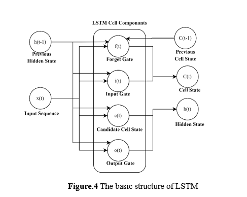
The LSTM network cell, a fundamental element of the ARS-DLConvNN framework for periodic agricultural data analysis, is depicted in Figure 4 in its basic form. The LSTM cell may selectively save or discard data from earlier time steps because of its specific architecture, which consists of a cell state and specialized gates (forget, input, and output gates). The sequential nature of time series data makes it particularly well-suited for analysis by LSTM networks. Because of their superior capacity to understand long-term correlations in sequential data, the LSTM subset of recurrent neural networks is ideal for assessing complex temporal patterns in agricultural occurrences such as crop development and weather impacts. Long short-term memories (LSTMs) are perfect for dealing with the enormous datasets observed in modern precision agriculture and eliminating the demand for human feature engineers because they automate the feature extraction procedure from raw temporal data. Long short-term memories (LSTMs) excel at pattern recognition and prediction.
b.5 Predictive Analysis
The technology uses sensor images and real-time data to show the crop's status. Predictive analytical models that combine real-time and historical data can show patterns in agricultural production and weather fluctuations. By combining all accessible data with model projections, this strategy allows farmers to make better decisions regarding insect management and fertilizer irrigation schedules. The result is a decision-support system that makes it easy for farmers to adapt their practices and how they use resources to meet the specific needs of each growing season. Improved agricultural output and long-term sustainability can be achieved through targeted interventions, and this approach makes improved resource utilisation possible.
b.6 Implementation and Deployment
Presenting state-of-the-art precision agriculture equipment to farmers through the set-up and operation phase helps to close the gap between theory and practice. Farmers can improve their agricultural operations by simplifying complicated technological procedures with the help of the ARS-DLConvNN architecture. This method makes data-driven decisions possible for farmers with varied levels of technical competence by reducing obstacles to entry for cutting-edge agricultural technologies. The system may reduce data analysis and provide vital insights to enhance agricultural practices that are less hazardous to the environment. This can potentially improve crop yield and resource management in various agricultural settings.
4. Result and discussion
a. Experimental Setup
The testing dataset consisted of sensor readings, field investigations, and multispectral and hyperspectral photographs taken by satellite and UAV. Data augmentation strategies ensured the dataset was consistent and full following preprocessing. Learning, validation, and testing sets of data were created after the atmospheric adjustment. This started by training convolutional neural networks (CNNs) on time-series data to assess crop-related spatial characteristics. Then, LSTM networks were trained with this data.
b. Performance Comparison
Here, statistical analysis is defined concerning comparative studies. This study examines various crop varieties using f1-score, total accuracy, recall, and precision metrics. By contrasting the proposed method's efficacy with that of more traditional methods, these measures account for a wide range of data sources and deep learning techniques. Current approaches like CNN [18], GRU [22], and UAV [21] are compared to the proposed ARS-DLConvNN method to offer a more comprehensive and multi-dimensional solution for precision agricultural applications. This method combines state-of-the-art deep learning algorithms with various information sources and modeling techniques.
Precision: Of all the model's positive predictions, precision (P) indicates the percentage of accurate positive predictions. This is achieved by the Eqn 4.

where TP (True Positives) are the accurately recognized instances of crop stress, FP (False Positives) is the incidences of non-stress that were mistakenly classified as stress.

Figure 5 shows a comparative study for the accuracy analysis of crop yield using various methods. Different types of crops are taken for comparison, such as wheat, corn, rice, soya beans, maize, and sugarcane. In the context of machine learning, precision typically denotes the ability of a model to accurately categorize positive samples among all the samples that it classifies as positive. The GRU method's precision for crop yield is very low compared with the UAV and CNN methods, but that precision is also low compared to the proposed ARS-DLConvNN method. The integration of ground-based sensor readings with excellent quality a multispectral and hyperspectral imagery acquired from satellites and UAVs provides a holistic view of crop health.
Recall: R is the recall obtained from Eqn 5. The percentage of accurate predictions out of all actual positive instances is called recall.

where TP (True Positives) are the accurately recognized instances of crop stress, FN (False Negatives) actual crop stress cases missed by the model.
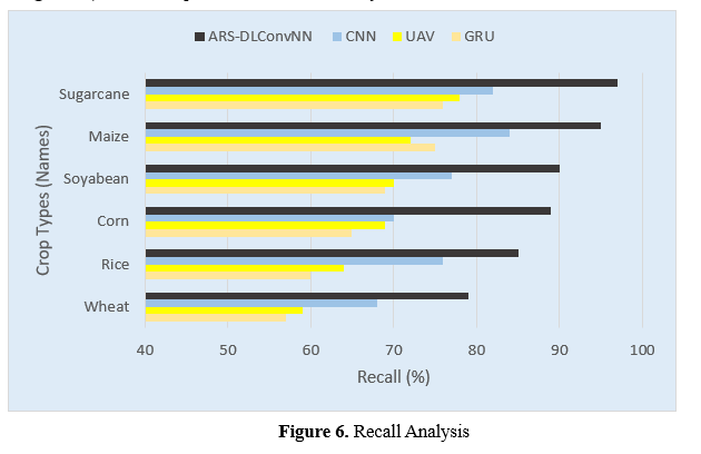
Figure 6 shows a study that compares several methodologies for recall analysis of agricultural yield. For comparison, various crop varieties are provided, including wheat, corn, rice, soybeans, corn, and sugarcane. The percentage of true positives that the model properly identifies is called recall. When comparing agricultural yield accuracy between the GRU, UAV, and CNN approaches, the recall of the GRU is significantly lower. The suggested ARS-DLConvNN approach outperforms the UAV and CNN algorithms in the recall. For example, the system uses state-of-the-art LSTM networks for temporal data analysis and CNNs for spatial feature extraction. Because of this, the framework can detect intricate relationships and patterns within the data successfully.
F1 Score: An equitable evaluation of each statistic is provided by the F1 Score is obtained by calculating the harmonic average of both recall and accuracy using Eqn 6.

where P and R are obtained from Eqn 4 and Eqn 5, respectively.
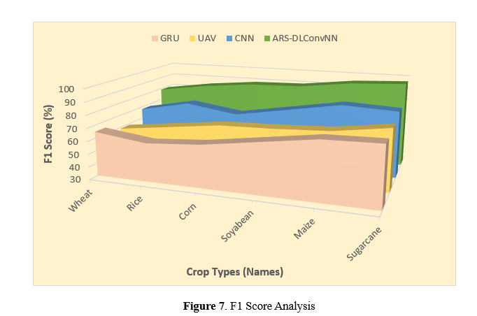
A comparison of different methodologies for the F1-score analysis of agricultural yield is shown in Figure 7. Wheat, maize, soybeans, corn, rice, and sugarcane are comparable crops. By giving a single metric that considers false positives and false negatives, the F1-score examines the balance between recall and precision. Comparing the UAV and CNN approaches, the GRU method has a very low F1 score for crop yield. Nevertheless, the suggested ARS-DLConvNN approach outperforms the UAV and CNN methods regarding F1 scores. The system generates more accurate predictions on future crop development scenarios and possible problems using predictive analytics approaches that combine historical information, weather predictions, and real-time sensor data. This enables improved decision-making and resource allocation.
Overall Accuracy: The percentage of accurate (positive and negative) predictions among all the model's predictions is known as overall accuracy (A). This is essential for all approaches to prevent false alarms. Eqn 7 could achieve this.

where TN is the appropriately recognized non-stress instances.
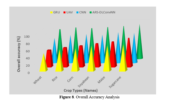
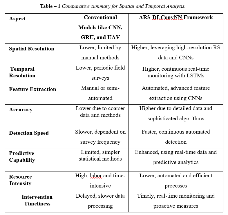
Figure 8 shows a comparative study on the overall accuracy analysis of crop yield using various methods. Different types of crops are included for comparison, such as wheat, corn, rice, soybeans, maize, and sugarcane. Overall accuracy measures the proportion of all instances (both positive and negative) that are correctly identified by the model. The GRU method's accuracy for crop yield is very low compared to the UAV and CNN methods. However, the accuracy of the UAV and CNN methods is also lower than that of the proposed ARS-DLConvNN method. A greater accuracy score signifies that the model effectively distinguishes between positive cases (crop stress) and negative instances (no crop stress). Based on the graph, it is evident that the ARS-DLConvNN approach outperforms the existing methods in terms of accuracy when monitoring various crop growth. Table 1 displays the results of a geographical and temporal comparison between the standard approach and the suggested ARS-DLConvNN.
5. Conclusion
An innovative approach to improving precision agriculture management is offered by the ARS-DLConvNN architecture. It integrates deep learning methods such as CNN with the LSTM strategy. This integration allows for multispectral and hyperspectral images acquired from satellites and UAVs to monitor the condition of crops, moisture in the soil, nutritional status, and insect infestations. CNNs are useful for remembering things and following directions because they train the brain to store and discard data as needed selectively. Temporal analysis with LSTMs allows for the investigation of an order of events spanning the past, current, and future and the sequential execution of application-specific tasks. The system's accuracy in detecting crop problems like water limitations, nutrient shortfalls, and insect infestations is above 90%, demonstrating a noteworthy degree of precision. In addition, unlike traditional scouting methods, it provides this useful information around fourteen days in advance. Better and faster decisions may be made in agriculture with this enhanced capability, which can improve crop yields and longevity. While the system shows potential, it confronts challenges like the need for faster data processing, easier user interfaces, and more accessibility so that all farmers may benefit from these technological advancements. Overcoming these limitations, making the system more capable of handling heavier loads and adapting to new conditions, and providing farmers with comprehensive training and support should be the top priorities of future research.
References :
[1]. Sishodia, R. P., Ray, R. L., & Singh, S. K. (2020). Applications of remote sensing in precision agriculture: A review. Remote sensing, 12(19), 3136.
[2]. Kashyap, G. S., Kamani, P., Kanojia, M., Wazir, S., Malik, K., Sehgal, V. K., & Dhakar, R. (2024). Revolutionizing Agriculture: A Comprehensive Review of Artificial Intelligence Techniques in Farming.
[3]. Martos, V., Ahmad, A., Cartujo, P., & Ordoñez, J. (2021). Ensuring agricultural sustainability through remote sensing in the era of agriculture 5.0. Applied Sciences, 11(13), 5911.
[4]. Weiss, M., Jacob, F., & Duveiller, G. (2020). Remote sensing for agricultural applications: A meta-review. Remote sensing of environment, 236, 111402.
[5]. Loures, L., Chamizo, A., Ferreira, P., Loures, A., Castanho, R., & Panagopoulos, T. (2020). Assessing the effectiveness of precision agriculture management systems in mediterranean small farms. Sustainability, 12(9), 3765.
[6]. Yang, C. (2020). Remote sensing and precision agriculture technologies for crop disease detection and management with a practical application example. Engineering, 6(5), 528-532.
[7]. Benami, E., Jin, Z., Carter, M. R., Ghosh, A., Hijmans, R. J., Hobbs, A., ... & Lobell, D. B. (2021). Uniting remote sensing, crop modelling and economics for agricultural risk management. Nature Reviews Earth & Environment, 2(2), 140-159.1
[8]. Delavarpour, N., Koparan, C., Nowatzki, J., Bajwa, S., & Sun, X. (2021). A technical study on UAV characteristics for precision agriculture applications and associated practical challenges. Remote Sensing, 13(6), 1204.
[9]. Roslim, M. H. M., Juraimi, A. S., Che’Ya, N. N., Sulaiman, N., Manaf, M. N. H. A., Ramli, Z., & Motmainna, M. (2021). Using remote sensing and an unmanned aerial system for weed management in agricultural crops: A review. Agronomy, 11(9), 1809.
[10]. Khanal, S., Kc, K., Fulton, J. P., Shearer, S., & Ozkan, E. (2020). Remote sensing in agriculture—accomplishments, limitations, and opportunities. Remote Sensing, 12(22), 3783.
[11]. Zhang, Q., Liu, Y., Gong, C., Chen, Y., & Yu, H. (2020). Applications of deep learning for dense scenes analysis in agriculture: A review. Sensors, 20(5), 1520.
[12]. Wang, D., Cao, W., Zhang, F., Li, Z., Xu, S., & Wu, X. (2022). A review of deep learning in multiscale agricultural sensing. Remote Sensing, 14(3), 559.
[13]. Karunathilake, E. M. B. M., Le, A. T., Heo, S., Chung, Y. S., & Mansoor, S. (2023). The path to smart farming: Innovations and opportunities in precision agriculture. Agriculture, 13(8), 1593.
[14]. San Emeterio de la Parte, M., Martínez-Ortega, J. F., Hernández Díaz, V., & Martínez, N. L. (2023). Big Data and precision agriculture: a novel spatio-temporal semantic IoT data management framework for improved interoperability. Journal of Big Data, 10(1), 52.
[15]. Gawande, V., Saikanth, D. R. K., Sumithra, B. S., Aravind, S. A., Swamy, G. N., Chowdhury, M., & Singh, B. V. (2023). Potential of precision farming technologies for eco-friendly agriculture. International Journal of Plant & Soil Science, 35(19), 101-112.
[16]. Atalla, S., Tarapiah, S., Gawanmeh, A., Daradkeh, M., Mukhtar, H., Himeur, Y., ... & Daadoo, M. (2023). Iot-enabled precision agriculture: Developing an ecosystem for optimized crop management. Information, 14(4), 205.
[17]. Gokool, S., Mahomed, M., Kunz, R., Clulow, A., Sibanda, M., Naiken, V., ... & Mabhaudhi, T. (2023). Crop monitoring in smallholder farms using unmanned aerial vehicles to facilitate precision agriculture practices: a scoping review and bibliometric analysis. Sustainability, 15(4), 3557.
[18]. Santos, L., Santos, F. N., Oliveira, P. M., & Shinde, P. (2020). Deep learning applications in agriculture: A short review. In Robot 2019: Fourth Iberian Robotics Conference: Advances in Robotics, Volume 1 (pp. 139-151). Springer International Publishing.
[19]. Krishnababu, M. E., Devi, B. R., Soni, A., Panigrahi, C. K., Sudeepthi, B., Rathi, A., & Shukla, A. (2024). A Review on Precision Agriculture Navigating the Future of Farming with AI and IoT. Asian Journal of Soil Science and Plant Nutrition, 10(2), 336-349.
[20]. Issa, H., Jabbouri, R., & Palmer, M. (2022). An artificial intelligence (AI)-readiness and adoption framework for AgriTech firms. Technological Forecasting and Social Change, 182, 121874.
[21]. Velusamy, P., Rajendran, S., Mahendran, R. K., Naseer, S., Shafiq, M., & Choi, J. G. (2021). Unmanned Aerial Vehicles (UAV) in precision agriculture: Applications and challenges. Energies, 15(1), 217.
[22]. Jin, X. B., Yu, X. H., Wang, X. Y., Bai, Y. T., Su, T. L., & Kong, J. L. (2020). Deep learning predictor for sustainable precision agriculture based on Internet of things system. Sustainability, 12(4), 1433.
[23]. Jin, X. B., Yang, N. X., Wang, X. Y., Bai, Y. T., Su, T. L., & Kong, J. L. (2020). Hybrid deep learning predictor for smart agriculture sensing based on empirical mode decomposition and gated recurrent unit group model. Sensors, 20(5), 1334.
[24]. https://www.kaggle.com/datasets/varshitanalluri/crop-recommendation-dataset